Beneath our bustling cities and sprawling fields lies a hidden world of water, a silent, slow-moving resource that sustains billions. These vast underground reservoirs, known as aquifers, are Earth’s secret oceans. But we are draining them at a terrifying and unsustainable rate. This isn’t a distant, abstract problem; it’s a slow-motion geographic disaster unfolding directly underfoot, a classic tragedy of the commons where a shared, life-giving resource is being depleted for short-term gain.
To understand this invisible crisis, we must first journey underground and explore the geography of these subterranean seas.
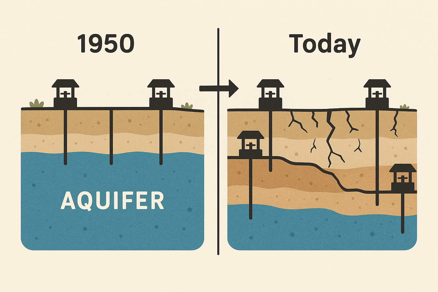
The Anatomy of an Aquifer
Imagine a giant, subterranean sponge. An aquifer is not an underground lake or river in the conventional sense, but rather a layer of porous rock, sand, and gravel saturated with water. This groundwater accumulates over centuries, even millennia, as rainwater and snowmelt slowly percolate down through the soil, a process called recharge. They are, in essence, geological savings accounts for water, built up over vast timescales.
However, not all groundwater is created equal. Many of the world’s largest aquifers contain what geologists call fossil water—ancient water that seeped underground during wetter climates, thousands or even millions of years ago, and is now sealed off from any meaningful modern recharge. When we pump this water, we are not just borrowing from a slow-to-refill account; we are mining a finite, non-renewable resource.
Mapping the Global Depletion Hotspots
The geography of aquifer depletion traces a map of humanity’s greatest agricultural and urban centers. Using advanced satellite technology like NASA’s GRACE (Gravity Recovery and Climate Experiment), scientists can now “weigh” the water content of these aquifers from space, revealing the alarming scale of the deficit. Here are some of the most critical hotspots.
The Ogallala Aquifer, United States
Stretching beneath eight states from South Dakota to Texas, the Ogallala (or High Plains Aquifer) is the lifeblood of America’s breadbasket. It irrigates roughly one-third of the nation’s crops, supporting a $20 billion-a-year industry. But this agricultural miracle is fueled by fossil water. Since the mid-20th century, powerful pumps have drawn water out far faster than nature can replace it. In parts of Kansas and Texas, the water table has dropped by over 100 feet. As wells run dry, the very geography of American agriculture is being forced to change, with some farmers reverting to less profitable dry-land farming or abandoning their land altogether.
The North China Plain, China
Home to over 200 million people and the epicenter of China’s wheat and maize production, the North China Plain is one of the most water-stressed regions on Earth. The immense thirst of megacities like Beijing and Tianjin, combined with intensive agriculture, has created massive “cones of depression” in the water table. The consequences are starkly visible on the surface: widespread land subsidence. As the aquifer compacts, the ground above it sinks, damaging buildings, cracking roads, and threatening the integrity of critical infrastructure like the country’s famous high-speed rail lines.
The Indus Basin Aquifer, India and Pakistan
Straddling the border of two nuclear-armed neighbors, the Indus Basin is perhaps the most over-stressed aquifer system in the world. It supports the livelihoods of hundreds of millions of people in one of the most densely populated regions on the planet. The Green Revolution of the 1960s and 70s, which introduced high-yield crops, also ushered in an era of intensive groundwater pumping. Today, farmers are drilling deeper and deeper, chasing a receding water table in a desperate race to the bottom that increases both their costs and the risk of pumping contaminated water.
The Human Geography Driving the Crisis
This crisis is a story of human geography—of where and how we choose to live, eat, and grow.
- The Agricultural Engine: Globally, agriculture accounts for approximately 70% of all groundwater withdrawals. Our modern food system is inextricably linked to the exploitation of these hidden reserves.
- The Thirst of Megacities: Urbanization concentrates water demand into small geographic areas. Cities like Mexico City, which was built on ancient lakebeds, are physically sinking as the aquifers beneath them are drained to supply taps and factories. Jakarta, the capital of Indonesia, is sinking so fast that the government is planning to relocate the entire capital.
- A Technological Trap: The invention and proliferation of high-capacity electric and diesel pumps after World War II turned a largely inaccessible resource into an easily tapped one. This technology allowed us to outpace the natural cycle of recharge, creating a structural deficit that grows with each passing year.
The Geographic Consequences: A Sinking, Salty Future
When we drain an aquifer, the consequences extend far beyond simply having less water. The physical geography of a region can be permanently altered.
Land Subsidence: As mentioned, when water is pumped from the pore spaces in rock and sediment, the land above can compact and sink. This is not a uniform, gentle settling. It’s an uneven process that damages buildings, bridges, and pipelines, and permanently reduces the aquifer’s ability to store water in the future.
Saltwater Intrusion: Along coastlines, a delicate balance exists between the dense saltwater of the ocean and the freshwater of the aquifer pressing outward. As coastal aquifers are over-pumped, this balance is disrupted, allowing saltwater to intrude and contaminate the remaining freshwater. This process is threatening the water supplies of coastal cities from Florida to the Mediterranean.
Drying Ecosystems: Groundwater is not isolated from the surface. It feeds springs, rivers, and wetlands, providing a crucial “baseflow” that keeps them alive during dry periods. As water tables fall, these connections are severed. Rivers that once flowed year-round become seasonal, and vital wetland ecosystems disappear, taking their unique biodiversity with them.
Navigating a Collision Course
Aquifer depletion is a quiet, insidious crisis. Because it happens underground and over decades, it lacks the dramatic urgency of a flood or an earthquake. Yet it is a collision course between our current patterns of consumption and the physical limits of our planet. Tackling it requires a shift in perspective—from mining water to managing it.
Solutions exist, from deploying hyper-efficient drip irrigation and practicing rainwater harvesting to large-scale projects like Managed Aquifer Recharge (MAR), where excess surface water is intentionally directed back underground. But most importantly, it requires acknowledging the true value of this invisible resource and creating policies that protect the common inheritance we all depend on, hidden just beneath the surface.