Ever dug a hole in the sand at the beach on a hot day? The deeper you go, the cooler and damper the sand becomes. Now, imagine digging the deepest hole in the world. As you descend past the first few dozen feet, a strange thing happens: the trend reverses. It starts to get warmer. Go deeper still, and it becomes scorching hot. This fundamental feature of our planet is known as the geothermal gradient, and it’s the slow, steady heartbeat of a geologically active world.
What is the Geothermal Gradient?
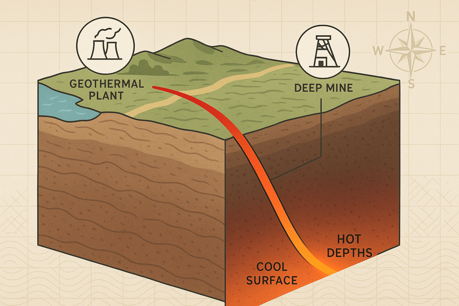
In simple terms, the geothermal gradient is the rate at which the temperature of the Earth’s interior increases with depth. While it varies from place to place, the global average in the continental crust is about 25–30 °C per kilometer (or roughly 1 °F for every 70 feet of depth).
This internal heat comes from two primary sources:
- Primordial Heat: This is the residual heat left over from the planet’s violent formation about 4.6 billion years ago. The energy from planetary accretion (countless meteorites colliding) and gravitational compression was immense, and the Earth’s core is still cooling down from this initial state.
- Radiogenic Heat: This is heat produced by the continuous natural decay of radioactive isotopes, primarily uranium, thorium, and potassium, distributed throughout the Earth’s crust and mantle. Think of it as a slow-burning, planet-wide nuclear furnace. In the crust, this is the dominant source of heat.
As we journey (figuratively) towards the Earth’s center, the temperature climbs dramatically. The mantle sizzles at thousands of degrees Celsius, while the outer core is a churning ball of liquid iron and nickel hotter than 4,400 °C. At the very center, the solid inner core is estimated to be around 6,000 °C—as hot as the surface of the sun—kept solid only by unimaginable pressure.
A Patchwork of Heat: Geographical Variations
The average geothermal gradient is just that—an average. In reality, the planet’s heat is not distributed evenly. The local gradient is heavily influenced by a region’s tectonic setting, creating a global patchwork of hot and cold spots.
Tectonic Plate Boundaries
The most dramatic variations occur along the edges of Earth’s tectonic plates.
- Divergent Boundaries: Where plates pull apart, like the Mid-Atlantic Ridge or the East African Rift Valley, hot magma from the mantle rises closer to the surface. This creates an extremely high geothermal gradient. Iceland sits atop the Mid-Atlantic Ridge, making it a global hotspot for geothermal activity.
- Convergent Boundaries: Where plates collide, the situation is more complex. In subduction zones, where a cold, dense oceanic plate dives beneath a continental plate (like along the coast of Peru and Chile), it actually cools the upper mantle, leading to a lower initial gradient. However, the friction and melting of the subducting plate eventually generate magma that rises to form volcanic arcs, such as the Andes Mountains or the islands of Japan. These volcanic zones have an intensely high local gradient.
Intraplate Hotspots and Stable Cratons
You don’t have to be at a plate edge to feel the heat. Some areas in the middle of plates are exceptionally hot or cool.
- Mantle Plumes (Hotspots): These are columns of abnormally hot rock rising from deep within the mantle. When a plume reaches the base of the crust, it creates areas of intense volcanism and a very high geothermal gradient. Yellowstone National Park in the United States is a prime example, sitting atop a massive hotspot that powers its famous geysers and hot springs. The Hawaiian Islands are another, formed as the Pacific Plate drifts over a stationary mantle plume.
- Stable Cratons: In contrast, the ancient, stable hearts of continents, known as cratons, have very thick, cold crust. Areas like the Canadian Shield or the Siberian Platform have been geologically inactive for billions of years and possess a much lower-than-average geothermal gradient.
Harnessing the Planet’s Heat: Geothermal Energy
This geographical variation in the geothermal gradient is not just an academic curiosity; it has profound implications for human geography, particularly in our search for sustainable energy. Geothermal energy harnesses this internal heat to generate electricity and for direct heating.
Countries fortunate enough to be located in regions with a high gradient are leading the way:
- Iceland: The poster child for geothermal energy. The entire capital city, Reykjavik, is heated by geothermal water. Over 25% of the country’s electricity comes from geothermal power plants that tap into the superheated water and steam just below the surface.
- The Ring of Fire: Countries situated along this tectonically active belt are major geothermal producers. The Philippines and Indonesia have invested heavily in geothermal power, tapping into the heat from their volcanic landscapes.
- Kenya: Located in the East African Rift Valley, Kenya is a leader in geothermal energy in Africa, using the rift’s high heat flow to power its growing economy.
- United States: While not a leader in percentage terms, the U.S. is the world’s largest producer of geothermal electricity in absolute terms. Most of this comes from “The Geysers” geothermal field in California, the largest of its kind in the world.
Geothermal power plants typically work by drilling wells into hot reservoirs to release steam, which then turns a turbine to generate electricity. In areas with slightly lower temperatures, binary cycle plants use the hot water to boil a secondary fluid with a much lower boiling point, which then turns the turbine. This technology is expanding the geographic potential for geothermal power beyond the world’s most extreme hotspots.
The Gradient’s Influence on Landscapes and Geology
Beyond energy, the geothermal gradient is a silent, powerful force shaping our planet’s physical geography.
- Metamorphism: The heat from the gradient is a key ingredient in metamorphism—the process that changes one type of rock into another. For example, as shale is buried deeper and subjected to higher temperatures, it transforms into slate, then phyllite, schist, and finally gneiss.
- Volcanoes and Geysers: The most spectacular surface expressions of a high geothermal gradient are volcanoes, geysers, fumaroles, and hot springs. These features are direct windows into the hot processes occurring below and are hallmarks of geologically active regions like New Zealand’s Taupo Volcanic Zone or Chile’s El Tatio geyser field.
- Hydrothermal Vents: On the ocean floor, especially along mid-ocean ridges, the high geothermal gradient drives the formation of hydrothermal vents. Seawater seeps into the crust, is superheated, and then erupts back out, laden with dissolved minerals that support unique ecosystems thriving in total darkness.
The geothermal gradient is more than just a measurement; it is a fundamental driver of the planet. It dictates where volcanoes will rise and where the crust is stable, it forges new rocks deep underground, and it offers humanity a clean, reliable source of power. It’s a constant reminder that the ground beneath our feet is not cold and inert, but a dynamic and fiery system that has shaped our world and will continue to do so for eons to come.