What is Isostasy? The Earth’s Balancing Act
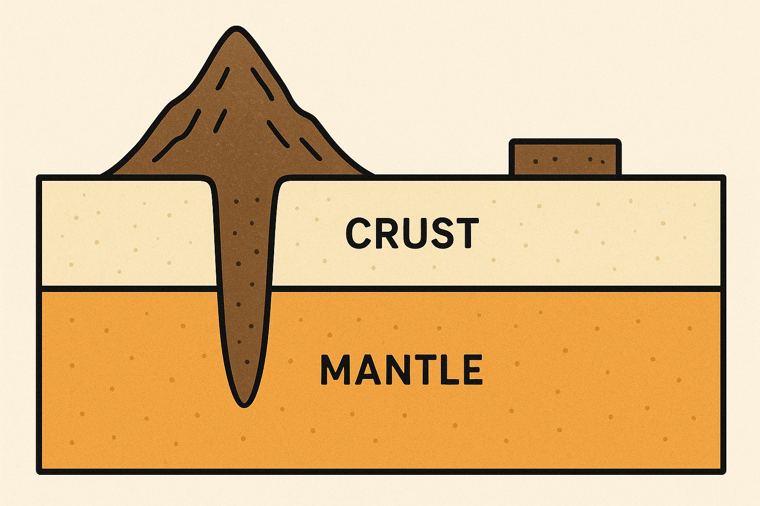
The term “isostasy” comes from the Greek words ísos, meaning “equal”, and stásis, meaning “standing still.” It describes the state of gravitational equilibrium between the Earth’s crust and the denser mantle that lies beneath it. In simpler terms, it’s the principle that the rigid outer layer of the Earth, the lithosphere, “floats” on the more plastic, slowly flowing layer of the upper mantle, known as the asthenosphere.
Think of the lithosphere not as a single, uniform shell, but as a series of blocks of varying thickness and density. Continental crust, which forms our landmasses and mountains, is thicker but less dense than the oceanic crust that lines the ocean floors. Both of these are significantly less dense than the hot, pliable rock of the asthenosphere they rest upon. Just as a log floats in water, the less dense crustal blocks float on the denser mantle. Isostasy is the process of these blocks finding their equilibrium level, their “flotation” point.
The Iceberg Analogy: Seeing a Mountain’s Roots
The most powerful way to visualize isostasy is by thinking of an iceberg. When you see an iceberg from a ship, you’re only witnessing about 10% of its total mass. The other 90% is submerged, a vast, unseen “root” that provides the buoyant support for the visible peak. The taller the iceberg is above the water, the deeper its root must extend into the water to support it.
Mountains work in precisely the same way. The towering peaks of the Himalayas or the Andes that we see scraping the sky are just the visible part. Beneath them, a massive root of crustal rock plunges deep into the mantle. The enormous mass of the mountain range pushes the lithosphere down into the asthenosphere. The greater the elevation of the mountain range, the deeper its crustal root.
- The Himalayas: As the world’s tallest mountain range, formed by the ongoing collision of the Indian and Eurasian tectonic plates, the Himalayas have the world’s deepest mountain root. The crust here is estimated to be over 70 kilometers (about 45 miles) thick, compared to an average continental crust thickness of around 35-40 kilometers.
- The Andes: Running along the western edge of South America, the Andes are another prime example. The subduction of the Nazca plate under the South American plate has thickened the crust, creating majestic peaks supported by a deep crustal root.
Erosion and Isostatic Rebound: The Slow Rise
So, we understand that adding mass (building a mountain) causes the crust to sink. But what happens when you remove mass? This is where isostasy reveals one of its most fascinating consequences.
Mountains are under constant attack from the forces of erosion. Wind, rain, ice, and rivers relentlessly wear down their peaks, carrying sediment away to the lowlands and seas. You might think this process would simply wear the mountains down to nothing over millions of years. But isostasy has a different plan.
Let’s go back to our iceberg. What happens if you start to melt the top of it? As the iceberg loses mass, it becomes lighter. To maintain its equilibrium, it bobs upwards, exposing more of its submerged root. The same thing happens to mountains. As erosion strips away rock from the peaks, the overall weight of the mountain range decreases. This reduction in load allows the buoyant crustal root to push upwards, causing the entire range to slowly rise in a process known as isostatic rebound or uplift.
This is a geological balancing act on a grand scale. Erosion wears the top down, while isostatic rebound pushes the whole block up from below. This is why ancient mountain ranges, such as the Appalachians in the United States or the Scottish Highlands, still exist as mountains despite hundreds of millions of years of erosion. They have been slowly rising, bringing deeper rocks to the surface, for an incredibly long time.
A Clearer Example: Post-Glacial Rebound
Perhaps the most dramatic and measurable evidence of isostasy comes not from mountains, but from ice. During the last Ice Age, vast ice sheets, kilometers thick, covered large parts of North America and northern Europe (Scandinavia). The immense weight of this ice pushed the crust down into the mantle.
When the ice sheets melted around 10,000 years ago, that colossal weight was lifted. Just like a thumbprint disappearing from a piece of foam, the land began to rebound upwards. And it’s still happening today. Regions around Hudson Bay in Canada and along the coast of Finland are rising by as much as 1 centimeter per year. Ancient harbors are now inland, and new islands are slowly emerging from the sea—a direct, visible consequence of isostatic adjustment.
This principle also applies to the deposition of sediment in large river deltas, the filling of large artificial reservoirs, and the presence of massive ice sheets on Greenland and Antarctica today, which continue to depress the crust beneath them.
The Floating World
Isostasy transforms our view of the Earth’s surface from a static, rigid stage to a dynamic, floating stage. It reveals that the spectacular topography of our planet—from the deepest ocean trenches to the highest mountain peaks—is the result of a constant, slow-motion balancing act. The mountains are not just held up by the strength of rock; they are buoyed by the deep, unseen roots that float upon a sea of denser, flowing mantle. The ground beneath us is truly a world in motion, always striving for balance.