Imagine possessing a kind of technological x-ray vision, the ability to peer through the densest jungle canopies and see the secrets hidden on the forest floor. Picture stripping away miles of urban development to reveal the subtle, ancient scars on the earth beneath. This isn’t science fiction; it’s the reality of a groundbreaking technology called LIDAR, and it’s fundamentally changing how we understand the geography of our world, both past and present.
What is LIDAR? A Laser-Powered View of the World
LIDAR stands for Light Detection and Ranging. At its core, the concept is elegantly simple. Think of it like radar, but instead of using radio waves, it uses pulses of laser light. The process, typically carried out from an airplane or drone, works like this:
- A sensor fires millions of rapid laser pulses toward the ground.
- These pulses hit everything in their path—the top of a tree, a branch halfway down, and finally, the earth itself.
- A receiver on the sensor measures the precise time it takes for each pulse to reflect and return.
- By calculating this travel time, the system determines the exact distance to the object the pulse hit, creating a massive collection of data points.
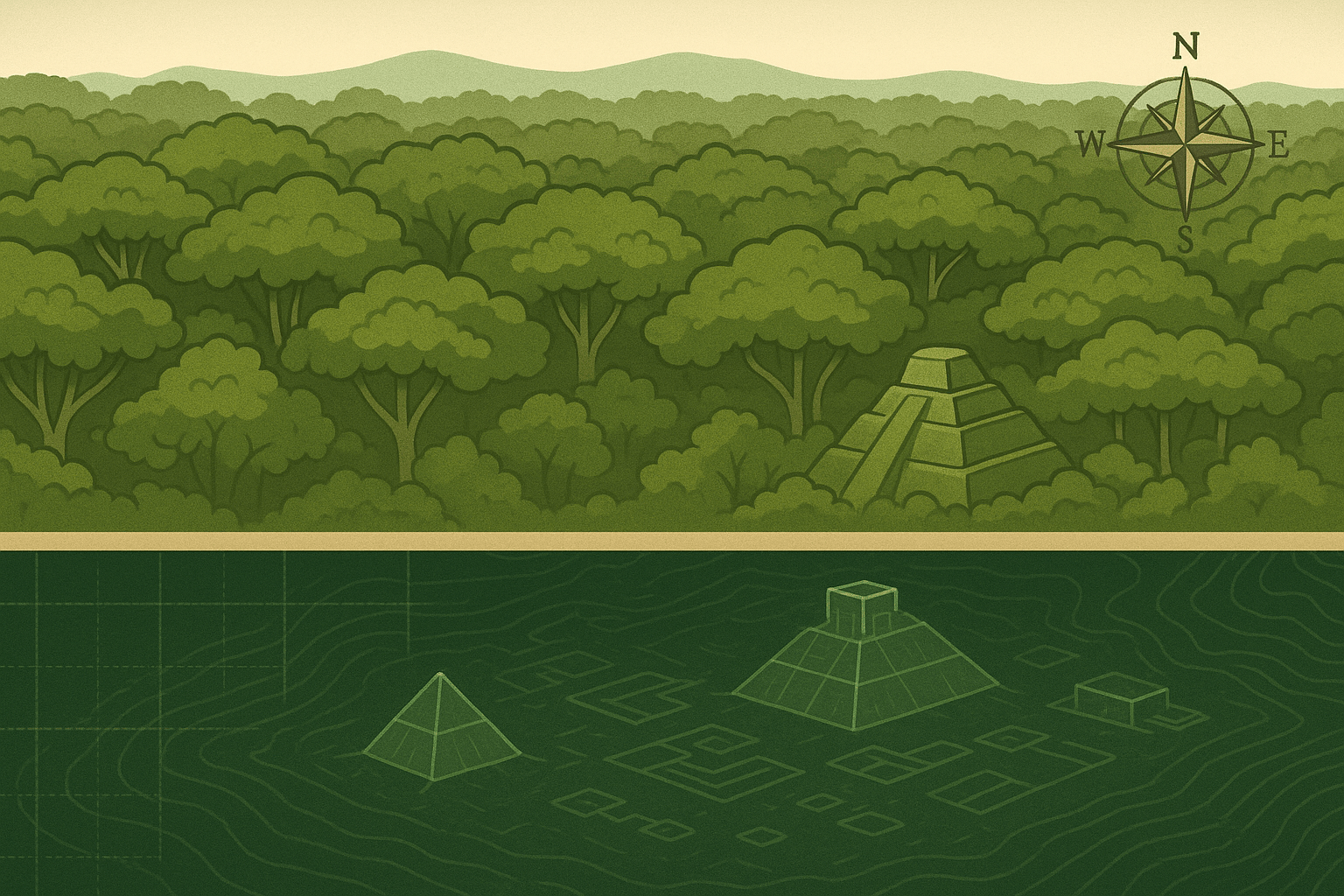
When combined, these millions of points form an incredibly detailed three-dimensional map called a “point cloud.” But here’s where the magic for geographers and archaeologists happens. The system records multiple “returns” for each pulse it sends out. The “first return” is often the top of the forest canopy, while the “last return” is typically the actual ground surface. By using powerful software to filter out all the returns except the last one, scientists can digitally “deforest” a landscape, creating a pristine, bare-earth model of the topography underneath.
Rewriting History: Uncovering Lost Cities in the Amazon
For centuries, the Amazon basin was viewed by many as a “pristine wilderness”, a vast, green expanse largely untouched by major human settlements before the arrival of Europeans. Ground-based archaeology was painstakingly slow, dangerous, and limited in scope. LIDAR has completely shattered this outdated view.
In the Mosetenes region of Bolivia, recent LIDAR surveys have revealed something astonishing: the sprawling, interconnected urban landscape of the Casarabe culture, which flourished between 500 and 1400 AD. Hidden for centuries under the thick jungle canopy, the data revealed a complex network of settlements complete with 70-foot-tall conical pyramids, vast platform mounds, and an intricate system of raised causeways and canals stretching for miles. This wasn’t a collection of small, isolated villages; it was a highly organized, low-density urbanism that reshaped its environment on a massive scale.
Similarly, in Belize, LIDAR mapping of the ancient Maya city of Caracol showed that it was far larger and more sophisticated than previously imagined. The laser data uncovered tens of thousands of agricultural terraces, reservoirs, and causeways connecting a dense network of suburban and rural settlements to the city’s core. These findings prove that pre-Columbian societies in the Americas were not only populous but were also brilliant engineers who managed their land and water resources with incredible ingenuity.
This application of LIDAR is a revolution for human geography. It forces us to rewrite textbooks and reconsider the history, population density, and environmental impact of ancient civilizations. We are now discovering that what we thought was “wild” nature was, in many cases, an engineered, human-shaped landscape.
Mapping the Earth’s Scars: Seeing Fault Lines in California
LIDAR’s power isn’t just for looking into the past; it’s a critical tool for understanding the dynamic, and sometimes dangerous, physical geography of the present. Nowhere is this more apparent than in seismically active regions like California.
The San Andreas Fault is famous, but it’s just one player in a complex web of faults that crisscross the state. Many of these faults are subtle and difficult to trace on the ground, their features obscured by vegetation, erosion, and urban development. This is a major problem for geologists and city planners trying to assess earthquake risk.
Enter airborne LIDAR. By creating high-resolution, bare-earth elevation models, geologists can spot the tell-tale signs of active faulting with unprecedented clarity. They can identify:
- Fault Scarps: Small, step-like features in the landscape where one side of a fault has moved vertically relative to the other.
- Offset Streams: Creeks and rivers that show a distinct “jog” or bend where a fault has shifted the ground horizontally beneath them.
- Linear Valleys: Straight, narrow valleys that have been carved out along the weakened rock of a fault line.
The Puget Sound Lidar Consortium in Washington State, for example, used this technology to map the Seattle Fault, a feature running directly through the metropolitan area that was previously poorly understood. The data revealed a history of large, powerful earthquakes, completely changing the seismic hazard assessment for the region.
This precision allows for more accurate hazard maps, informing building codes, infrastructure planning (where to place pipelines, bridges, and hospitals), and emergency response strategies. It’s a powerful example of how understanding physical geography can directly save lives and property.
A New Era of Geographic Discovery
LIDAR’s applications extend far beyond archaeology and seismology. In physical geography, it’s used to monitor coastal erosion with millimeter accuracy, create hyper-realistic floodplain maps for flood prediction, and calculate the volume of biomass in a forest for climate change studies.
As the technology becomes cheaper, faster, and more accessible—with compact sensors now fitting on small drones—we are entering a new era of discovery. We are building “digital twins” of our cities for better urban planning and creating maps of a detail once thought impossible. LIDAR has given us a new set of eyes, allowing us to see through the clutter of the modern world and the canopies of ancient forests. It reminds us that there are still incredible secrets lying just beneath the surface, waiting to be revealed by the power of light.