Imagine standing on solid ground, only to watch it slowly liquefy, slump, and slide away. Hillsides collapse into muddy torrents, forests of trees tilt over as if drunk, and vast craters appear in the landscape seemingly overnight. This isn’t a scene from a disaster movie; it’s a geographical process unfolding across the Arctic and sub-Arctic right now. It’s called thermokarst, and it’s the dramatic, erosional consequence of thawing permafrost.
As our planet warms, this “runaway slope” phenomenon is actively redrawing the map of the world’s northern latitudes, impacting everything from global climate patterns to the foundations of homes and cities.
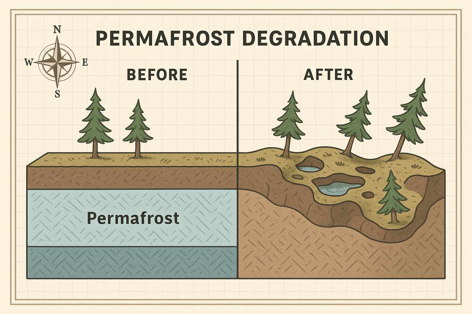
What is Permafrost? The Arctic’s Frozen Glue
To understand thermokarst, you first need to understand permafrost. Permafrost is any ground—soil, rock, or sediment—that remains frozen for at least two consecutive years. It covers a staggering 24% of the Northern Hemisphere’s exposed land, acting as a kind of frozen cement holding the vast landscapes of Siberia, Alaska, Northern Canada, and Greenland together.
Crucially, permafrost isn’t just frozen dirt. It’s a complex mixture that often contains huge amounts of pure ice. This ice can exist as small crystals in soil pores or, more dramatically, as massive underground wedges and layers of solid ice that have built up over thousands of years. This ice is the key to thermokarst’s power.
For millennia, this frozen ground has been stable. But with the Arctic warming nearly four times faster than the rest of the planet, the thermal balance is being upset. The frozen glue is starting to melt.
The Mechanics of Collapse
Thermokarst is what happens when the ice within the permafrost thaws. The process is simple but devastating:
- Thawing Begins: Rising air and ground temperatures cause the ice within the permafrost to melt.
- Volume Loss: Water takes up less space than ice. As the massive ice wedges melt, they leave behind empty spaces or voids in the ground.
- Structural Failure: The soil, now supersaturated with water and no longer supported by the ice, turns into an unstable, soupy slurry.
- Collapse: The ground surface above, its foundation gone, gives way. It can sink, slump, slide, and collapse, creating a chaotic and uneven terrain.
[Image: A simple cross-section diagram showing an intact ice wedge within the permafrost layer. A second panel shows the ice wedge melted, creating a water-filled void and causing the ground surface above to sink and form a thermokarst lake.]
This process isn’t a gentle, uniform sinking. It’s a disordered transformation that carves out distinctive and often bizarre features on the landscape.
The Telltale Signs: A Landscape in Motion
The geography of thermokarst is written in its unique landforms. Two of the most striking examples are thaw slumps and “drunken forests.”
Thaw Slumps: Runaway Scars on the Earth
A thaw slump, also known as a retrogressive thaw slump, is one of the most dynamic features of thermokarst. It often begins as a small landslide on a slope or riverbank that exposes a wall of ice-rich permafrost. Once exposed to the sun and warmer air, this ice face (the headwall) begins to melt rapidly.
As the ice melts, the mud and sediment above it slumps down and flows away, exposing more ice behind it. This creates a self-sustaining cycle where the slump actively eats its way backward into the hillside, growing larger each year. These features are horseshoe-shaped scars that can grow to be enormous—sometimes over a kilometer wide and tens of meters deep, moving millions of cubic meters of earth.
[Image: A dramatic satellite photo of a large thaw slump on a hillside in the Canadian Arctic, showing the characteristic horseshoe shape and the river of mud and sediment flowing from its base into a nearby lake.]
A chilling example is the Batagaika Crater in Siberia, Russia. Nicknamed the “gateway to the underworld,” it is the world’s largest thermokarst megaslump, currently over 1 kilometer long and 100 meters deep. It continues to expand by up to 30 meters per year, revealing ancient forests and animal remains frozen for millennia.
Drunken Forests
In flatter areas with ice-wedge polygons, the thawing is less of a landslide and more of an uneven sagging. As the ice wedges between blocks of tundra melt, the ground settles into a bumpy, pitted terrain. For the trees growing on this once-stable surface, the result is chaos.
Their roots lose their firm footing, and they begin to tilt at wild, haphazard angles. This creates a “drunken forest”, where the trees look like they’re struggling to stay upright. It’s a powerful visual indicator that the very ground beneath them is shifting and unstable.
[Image: A ground-level photograph of a “drunken forest” in Alaska, with spruce trees leaning in all directions against a backdrop of unsettled, hummocky ground.]
A Redrawn Map: The Human and Physical Geography
Thermokarst isn’t just creating strange landforms; it’s fundamentally altering Arctic geography and threatening the people who live there.
- Rerouted Rivers and New Lakes: The collapse of ground creates new depressions that fill with meltwater, forming countless new thermokarst lakes. These lakes can further accelerate thawing beneath them. Elsewhere, slumps can dam rivers or completely reroute their courses.
- Vanishing Coastlines: Along the Arctic coast, thawing permafrost makes cliffs and shorelines incredibly vulnerable to erosion from wave action. Some coastal villages in Alaska are losing over 20 meters of land per year, forcing communities to consider relocation.
- Crumbling Infrastructure: The human geography of the Arctic is built on the assumption of solid ground. Cities like Yakutsk in Russia, and communities across Alaska and Canada, rely on permafrost for stability. As it thaws, roads buckle, airport runways crack, building foundations fail, and critical infrastructure like the Trans-Alaska Pipeline faces immense engineering challenges to remain secure.
- Impact on Indigenous Livelihoods: For Indigenous peoples, the impacts are profound. Traditional hunting and travel routes become impassable. Ice cellars—natural freezers dug into the permafrost to store food—are failing. Ancestral sites are being lost to coastal erosion and slumping land.
The Global Feedback Loop
Perhaps the most alarming aspect of thermokarst is its role in a global climate feedback loop. Permafrost is an enormous reservoir of organic carbon—the remains of plants and animals that have been frozen for thousands of years. It holds an estimated 1,500 billion tons of carbon, roughly twice as much as is currently in Earth’s atmosphere.
As long as the ground is frozen, this carbon is locked away. But when it thaws, microbes wake up and begin to decompose this ancient organic matter. This process releases vast amounts of greenhouse gases—carbon dioxide (CO2) and, in the oxygen-poor, waterlogged conditions of thermokarst lakes and slumps, potent methane (CH4).
This creates a dangerous cycle: warming causes permafrost to thaw, which releases greenhouse gases, which causes more warming. This feedback is why scientists watch the runaway slopes of the Arctic with such concern.
The slumping hills and tilted forests of the north are more than just a regional phenomenon. They are a clear, dramatic, and accelerating signal from the front lines of a changing planet. The geography of the Arctic is being rewritten before our eyes, and the consequences will be felt far beyond its frozen shores.