Imagine a glacier, but one made of rock salt, buried miles deep and flowing over millions of years. It sounds like science fiction, but this is the very real world of salt tectonics. While plate tectonics gets the glory for shifting continents and raising mountain ranges, a quieter, stranger force is at work beneath our feet. Massive, ancient layers of salt, squeezed by the weight of overlying rock, behave like a viscous fluid, deforming, rising, and reshaping the Earth’s crust in profound ways that impact everything from the landscape of Louisiana to the economy of Brazil.
What is a Tectonic Process You Can Taste?
To understand salt tectonics, we first need to rethink our perception of salt. The halite on your dinner table is a crystalline mineral, and in bulk, it forms a sedimentary rock. When vast, ancient seas evaporated millions of years ago, they left behind immense layers of this salt, sometimes thousands of feet thick. Over geologic time, these layers were buried by heavier sediments like sand and mud, which compacted into sandstone and shale.
Here’s where the magic happens. Under the immense pressure and heat of deep burial, rock salt exhibits a remarkable property: it becomes ductile. It doesn’t melt, but it can flow, bend, and deform like extremely thick honey or glacial ice. Crucially, salt is also less dense than the compacted sediments piled on top of it. This creates a powerful buoyancy force. Like a cork held underwater, the low-density salt layer actively pushes its way upward through the heavier, more brittle rock above it. This process of salt movement is known as halokinesis.
The Architecture of Flowing Salt
This slow-motion ascent of salt is not a uniform process. It creates a fascinating and complex array of geological structures that are the primary focus for geologists and petroleum engineers studying these regions.
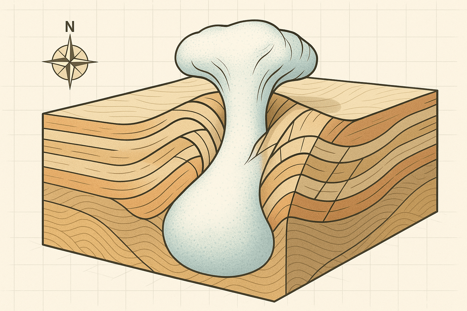
- Salt Domes (Diapirs): This is the classic salt structure. As the buoyant salt rises, it punches through the overlying rock layers, forming a column or mushroom-shaped intrusion called a diapir. These can be miles in diameter and rise close to the surface.
- Salt Glaciers (Namakiers): In arid regions where a salt diapir breaches the surface, the salt can be squeezed out and flow downhill, forming a feature that looks remarkably like an alpine glacier, but one made of rock salt.
- Salt Canopies: When multiple rising salt domes get close to the surface, they can spread out and merge laterally, forming a massive, continuous sheet of salt that covers a huge area.
- Salt Welds: These are the scars left behind. When a salt layer has completely moved out from between two other rock layers, the layers above and below collapse against each other, creating a “weld.”
Shaping the Surface: Salt’s Geographical Footprint
While these processes happen deep underground, their effects create distinct and sometimes dramatic features on the surface, shaping both physical and human geography.
From Marshy Plains to Towering Peaks
In a flat, low-lying coastal plain, the subtle upward push of a salt dome can be enough to create the only hills for miles around. The “Five Islands” of Louisiana—Avery, Weeks, Cote Blanche, Belle Isle, and Jefferson—are a perfect example. These prominent hills, rising starkly from the surrounding swamps, are simply the surface expression of underlying salt domes. The most famous, Avery Island, is not only a geological curiosity but also the home of Tabasco sauce, its existence entirely owed to the salt dome beneath it.
On a grander scale, salt tectonics can be a key ingredient in mountain building. The Zagros Mountains in Iran are a spectacular example. Here, the collision of the Arabian and Eurasian plates is folding the crust, but a thick layer of salt at the base acts as a lubricant, allowing the overlying rock layers to detach and fold more easily. The range is also famous for its stunning salt glaciers, where diapirs have breached the surface and salt flows openly across the desert landscape.
The Bumpy Seafloor of the Gulf of Mexico
Perhaps nowhere on Earth is the impact of salt tectonics more visible than on the seafloor of the Gulf of Mexico. Bathymetric maps reveal a bizarre, lumpy landscape of basins, ridges, and mounds. This chaotic topography is the direct result of thousands of salt structures moving in the subsurface. This has huge implications for human geography; laying pipelines and positioning deep-water oil rigs in this unstable, shifting environment is one of the great engineering challenges of our time.
The Economic Engine Underground
The strange behavior of salt is not just a geological curiosity; it is the foundation of immense economic wealth, primarily in the form of fossil fuels.
Black Gold and Salty Traps
As a salt dome pushes its way upward, it bends and shatters the rock layers it passes through. It domes the rock above it and creates faults on its flanks. These deformations create perfect geological traps. Oil and natural gas, which are lighter than water and migrate upwards through porous rock, get stuck against the impermeable salt or in the fault-bounded blocks alongside it. The vast oil and gas reserves of the Gulf of Mexico, the North Sea, and the massive “pre-salt” fields offshore of Brazil’s Santos Basin are all owed to salt tectonics.
More Than Just Seasoning
Beyond fossil fuels, salt domes are valuable resources in themselves. They are mined for their high-purity salt, as seen in historic mines like the Wieliczka Salt Mine in Poland, now a UNESCO World Heritage site. Furthermore, the impermeable nature of salt makes it an ideal medium for storage. Caverns leached out of salt domes are used to store the United States’ Strategic Petroleum Reserve and vast quantities of natural gas. In a more controversial application, the Waste Isolation Pilot Plant (WIPP) in New Mexico uses a deep salt formation to permanently dispose of nuclear waste, relying on the salt’s ability to flow and seal any fractures that might form.
The Unseen Shaper of Our World
From the subtle hills of the U.S. Gulf Coast to the dramatic peaks of Iran, from the chaotic seafloor to the deep energy reserves we depend on, salt tectonics is a hidden but immensely powerful force. It is a reminder that the Earth is a dynamic system, where even the most common of minerals can, over the vast expanse of geologic time, move mountains and shape civilizations. The next time you season your food, remember the geological power locked within that humble crystal—a true hidden mover of our world.