Stretching over 2,600 kilometers from the windswept fjords of Norway to the sun-drenched border of Spain, the Atlantic Wall stands as one of history’s most ambitious and ultimately futile feats of military engineering. Often imagined as a continuous, monolithic line of concrete, the reality was far more nuanced. It was not a wall in the traditional sense, but a complex, geographically-literate defensive system. To understand its design is to read the landscape of Western Europe through the eyes of its German architects—a chilling dialogue between concrete and coastline, strategy and topography.
The Third Reich, having blitzed its way across Europe, was faced with a monumental geographic problem: how to defend a continent’s edge against the largest amphibious invasion force ever conceived. The solution, overseen by Organisation Todt, was to treat the coast not as a line to be held uniformly, but as a series of interconnected geographic challenges, each demanding a unique architectural answer.
Reading the Tides and Sands: The Beaches of France
The coastline of France and the Low Countries, with its broad, sandy beaches, presented the most obvious threat. This was the landscape of amphibious assault, and the German defensive strategy was designed in direct response to its physical characteristics.
Nowhere is this more evident than in Normandy. The region’s infamous tidal range, among the largest in the world, created two distinct battlefields every twelve hours. The German planners, led by the astute Field Marshal Erwin Rommel, designed a lethal, multi-layered system to exploit this phenomenon.
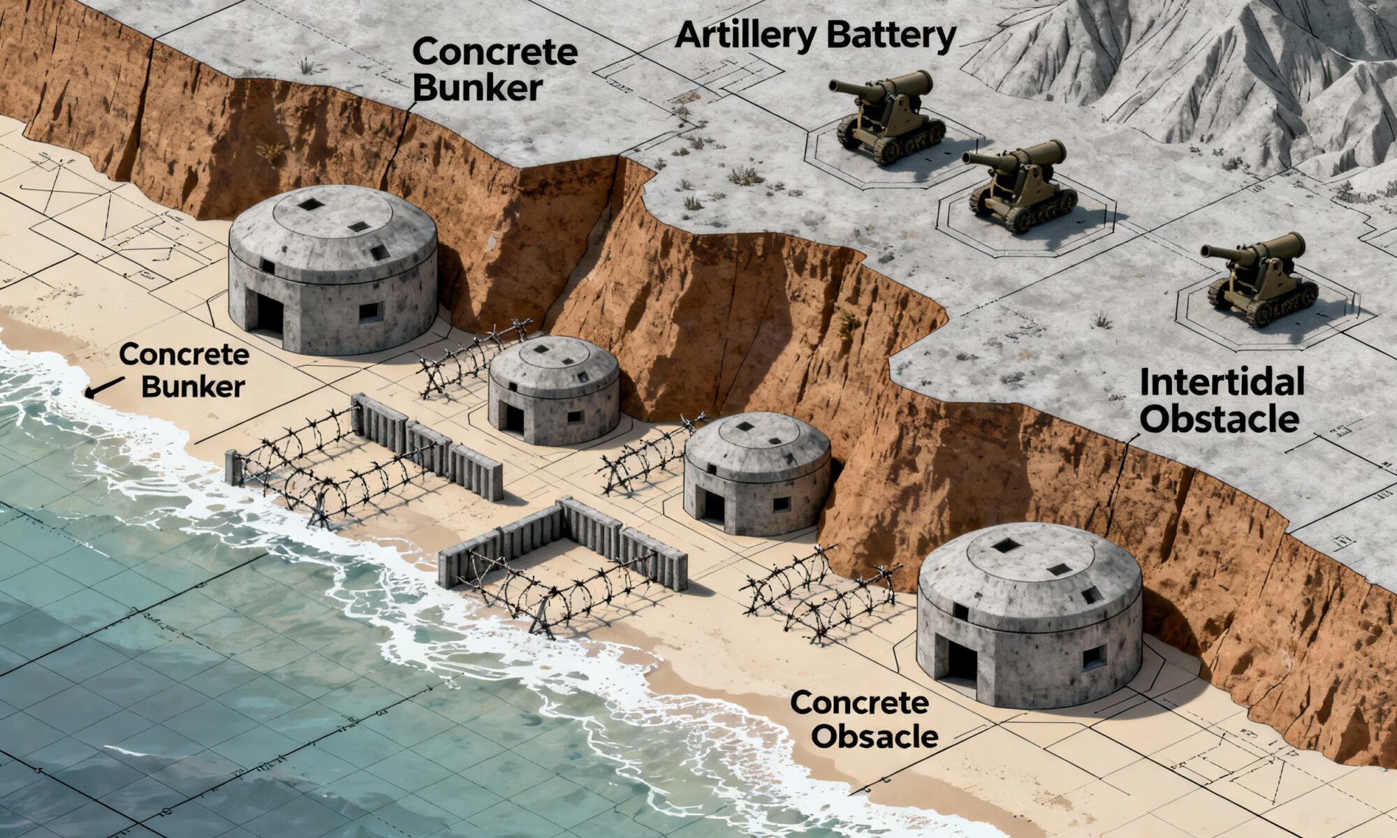
- Low Tide Defenses: At low tide, a vast expanse of wet sand would be exposed. This area was littered with a devil’s garden of obstacles. Angled logs known as “Rommel’s Asparagus” (Rommelspargel) were tipped with mines. Tetrahedra and Czech Hedgehogs—immense steel jacks—were designed to tear open the hulls of landing craft. These obstacles were not just physical barriers; they were engineered to force invading boats into pre-sighted kill zones.
- High Tide Defenses: As the tide rushed in, these obstacles would become partially or fully submerged, turning them into invisible ship-killers. The invasion would then have to land closer to the sea wall, directly in the face of the primary fortifications.
The topography of the beaches themselves dictated the placement of these fortifications. On Omaha Beach, the Germans leveraged the steep, commanding bluffs that rise directly from the sand. They embedded concrete casemates and machine-gun nests (Widerstandsnester or “resistance nests”) into the hillside, giving them a devastating field of plunging, enfilading fire across the entire length of the beach. The bluffs acted as a natural funnel, channeling the American soldiers into a perfectly engineered slaughterhouse. By contrast, the flatter terrain behind Utah Beach allowed for a defense-in-depth, with fortifications spread further inland to counter a more rapid advance.
Choke Points and Strategic Harbors: The “Fortress” Concept
The German command knew that an invasion could not be sustained on beaches alone. A successful Allied force would need a deep-water port to unload thousands of tons of supplies, vehicles, and men. This piece of human geography became the central focus of the Atlantic Wall’s grand strategy.
Major port cities like Cherbourg, Brest, Le Havre, and Calais were designated as Festungen—fortresses. The logic was brutal and simple: these ports were to be the most heavily defended points on the entire coast. They were bristling with the largest coastal artillery batteries, surrounded by concentric rings of bunkers, minefields, and anti-tank ditches. The goal was not just to prevent their capture, but to ensure that if they did fall, they would be so utterly destroyed in the fighting that they would be useless to the Allies for months.
The geographic “obviousness” of the Pas-de-Calais demonstrates this thinking perfectly. As the shortest point across the English Channel—just 34 kilometers—it was the most logical place for an invasion. Consequently, the Germans concentrated the 15th Army and the lion’s share of their heavy fortifications here. Massive gun batteries like the Todt Battery could hurl shells across the Channel. This geographic assumption was precisely what the Allies exploited with Operation Fortitude, a brilliant deception plan that convinced the Germans the main invasion would indeed land at Calais, keeping their strongest forces pinned down there even as the real landings began in the more lightly defended Normandy.
The Flanks: Adapting to Fjords and U-Boat Pens
The “wall” looked very different on its northern and southern flanks, where the geography and strategic objectives changed dramatically.
Festung Norwegen (Fortress Norway)
In Norway, the coastline is not one of gentle beaches but a jagged, complex maze of deep fjords, sheer cliffs, and thousands of islands. An amphibious landing on the scale of Normandy was nearly impossible. Here, the German strategic concerns were:
- Protecting naval assets and U-boat bases.
- Securing the sea route for Swedish iron ore, vital to the German war machine.
- Preventing British commando raids.
The defenses, therefore, were not beach-oriented. Instead, heavy coastal artillery batteries were perched at the entrances to key fjords, like those leading to Trondheim and Bergen. Their purpose was to act as “corks”, bottling up any enemy fleet that dared to enter the narrow channels. Observation posts sat on high peaks, using the very height of the mountains as a defensive tool.
The Bay of Biscay
Along the Atlantic coast of France, south of Brittany, the primary German asset was its network of colossal U-boat pens. In ports like Saint-Nazaire and Lorient, Organisation Todt constructed gargantuan, bomb-proof concrete shelters to protect the submarine fleet. The fortifications here were concentrated inward. While coastal batteries existed, the most formidable defenses were the immense anti-aircraft (Flak) towers built to protect the U-boat bases from air attack. The geographic logic was about protecting a critical industrial and military asset, with the coastline itself being a secondary concern.
A Landscape Frozen in Concrete
In the end, the Atlantic Wall failed. It was too long, too thin in most places, and predicated on a static conception of warfare. Yet, its ruins remain, a haunting testament to an unparalleled attempt to militarize an entire continent’s geography. It wasn’t a wall, but a system—a strategic interpretation of the landscape written in millions of tons of concrete. From the tidal calculations in Normandy to the fjord-denial batteries in Norway, every bunker and gun emplacement tells a story about the land and sea it was meant to command.