For centuries, these colossal figures and lines lay hidden in plain sight, their forms too large to be recognized by those walking upon them. It wasn’t until the advent of commercial aviation in the 1930s that their full scope was revealed to the world, sparking a wave of wonder, speculation, and intense scientific inquiry that continues to this day.
The World’s Largest Sketchbook: The Geography of the Pampa
To understand the Nazca Lines, one must first understand their unique geographical setting. The lines are located on a high, arid plateau, or pampa, situated between the Andes Mountains and the Pacific Ocean. This region is one of the driest places on Earth, a fact that is absolutely crucial to the lines’ survival.
The climate is exceptionally stable, with minimal rain and very little wind. The towering Andes block weather systems, creating a rain shadow effect that starves the desert of moisture. The surface of the pampa itself provides the perfect medium. It is covered by a layer of reddish-brown, iron oxide-coated pebbles, known as desert pavement. Beneath this dark veneer lies a contrasting sub-layer of yellowish-grey sand and clay.
This simple, two-toned geology is the secret to the lines’ creation and preservation. The stability of the ground, the lack of erosion from wind and water, and the stark color contrast have allowed these delicate etchings to endure for nearly two millennia.
Simple Methods, Monumental Results: How the Lines Were Made
Despite their otherworldly appearance, the construction of the Nazca Lines was surprisingly straightforward, requiring not advanced technology, but immense planning, precision, and communal effort. The Nazca people, who flourished in the region from roughly 100 BCE to 800 CE, created the geoglyphs by simply removing the 10- to 15-centimeter-deep top layer of reddish pebbles to expose the lighter ground beneath. The removed stones were often piled neatly along the borders of the lines, creating a subtle, raised edge.
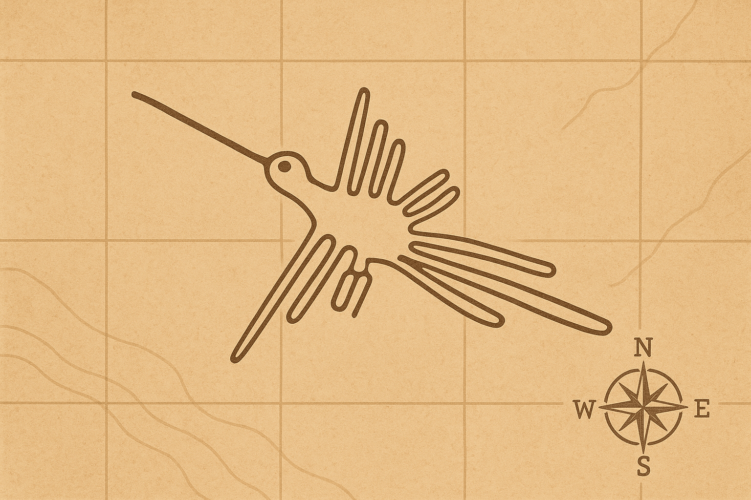
The Nazca designs fall into two main categories:
- Biomorphs: These are the most famous figures, representing animals, insects, and plants. Among the more than 70 biomorphs are a 135-meter-long hummingbird, a 46-meter-long spider, a monkey with a swirling tail, and a massive pelican. What is remarkable about these figures is that most are drawn with a single, continuous line that never crosses itself.
- Geometrics: Far more numerous than the biomorphs are the geometric shapes. These include hundreds of perfectly straight lines, some running for several kilometers, as well as immense trapezoids, triangles, spirals, and zigzags. These geometric forms often cut across the landscape and even over some of the earlier biomorphic designs, suggesting they were created at different times and perhaps for different purposes.
Archaeologists believe the Nazca used simple surveying tools—such as wooden stakes and long cords—to lay out their designs. By establishing a central line and measuring angles and distances, they could scale up small models or plans into the gigantic figures we see today. This demonstrates a sophisticated understanding of practical geometry and the ability to execute a plan on a massive scale.
The Enduring Enigma: Why Were the Lines Created?
The how is understood, but the *why* remains a subject of intense debate. Without any written records from the Nazca culture, researchers are left to interpret the lines based on archaeological and geographical evidence. Several compelling theories have emerged:
- An Astronomical Calendar: This was one of the earliest theories, championed by researcher Maria Reiche, the German “Lady of the Lines” who dedicated her life to studying and preserving them. She proposed that many lines align with the rising and setting of the sun and moon during solstices and equinoxes, and others point to the positions of key stars or constellations. The lines could have functioned as a massive astronomical calendar to help regulate an agricultural society dependent on predicting seasons.
- Ritual Walkways or Processional Paths: Many researchers believe the lines were created to be walked upon. The single, continuous stroke of the biomorphs suggests they were paths for religious processions or rituals. Walking the path of a sacred animal or a powerful shamanic symbol may have been a way for the community to connect with their deities, or apu, believed to reside in the surrounding mountains.
- Water Rituals and Resources: A powerful geographical theory connects the lines to the most vital resource in the desert: water. Some researchers have found correlations between the lines, particularly the trapezoids, and the locations of underground water sources, or puquios. The lines could have been ritual maps or offerings to gods to ensure a steady supply of water for their crops and communities.
- Shamanic Connections: Another theory suggests the figures represent shamanic spirit animals or creatures seen during hallucinogenic trances. The act of creating and walking these lines could have been part of a spiritual journey, connecting the physical world with the spirit realm.
While fringe theories involving aliens have captured the popular imagination, the scientific consensus is that the lines were created by the Nazca people for purposes deeply rooted in their relationship with their environment and their cosmology. It is highly likely that the lines served multiple, overlapping functions—part calendar, part temple, part map—that evolved over the centuries.
Mapping a Worldview: The Nazca’s Spatial Genius
Beyond the mystery of their purpose, the Nazca Lines offer a profound insight into the human geography and spatial understanding of their creators. They represent a culture that didn’t just inhabit a landscape; they transformed it into a sacred text. The pampa was not an empty wasteland but a canvas for expressing their cosmology, their societal needs, and their connection to the divine.
The sheer scale and precision of the lines reveal a society with remarkable social organization. Creating these geoglyphs would have required a shared vision, detailed planning, and the coordinated labor of many people over many generations. They demonstrate a mastery of translating a small, two-dimensional concept into a monumental, three-dimensional reality across an uneven landscape—a testament to their advanced spatial and geometric skills.
Today, the Nazca Lines are a UNESCO World Heritage site, fragile and threatened by climate change and human encroachment. They serve as a powerful reminder of a culture’s ingenuity and a testament to the universal human desire to make a mark on the world—to draw a line in the sand and have it speak across millennia.