A Message from the Depths
So, what exactly are Hunger Stones? At their core, they are rocks in a riverbed, naturally occurring or placed, that are only visible when the water recedes to a historic low. For centuries, when these stones became visible, local communities knew what was to come. A low river meant a season of drought, which in turn meant withered crops, a failed harvest, and consequently, famine and poverty.
But the disaster wasn’t limited to agriculture. Rivers like the Elbe and Rhine were the primary highways of commerce for centuries. Low water levels meant that barges and trade boats could not pass, grinding the transportation of food, salt, and other essential goods to a halt. This crippled local economies and isolated communities. In response, people began to chisel the dates of these devastating droughts into the stones, often adding dire warnings or lamentations. They transformed these rocks from simple geological features into powerful human-environment landmarks—a shared record of suffering and a grim forecast for anyone who saw them again.
Mapping the Memory: The Geography of the Hunger Stones
These stony chroniclers are not found everywhere; their locations are tied to the specific physical and human geography of Central Europe’s major river systems.
The most famous and heavily documented Hunger Stones lie along the Elbe River, which carves its path from the Krkonoše Mountains of the Czech Republic through Germany to the North Sea. The epicenter of Hunger Stone lore is the Czech town of Děčín, located in the northern part of the country before the river crosses into Germany. Here, nestled near the town’s main bridge, lies a large sandstone boulder that is arguably the most famous Hunger Stone in the world. Other stones have been recorded further downstream in German cities like Pirna, Dresden-Pillnitz, and Magdeburg.
The mighty Rhine River, a vital artery flowing from the Swiss Alps through Germany and the Netherlands, has its own collection of Hunger Stones. Notable examples have been documented near Worms-Rheindürkheim and Bingen am Rhein in Germany, areas historically dependent on the river for both agriculture (especially wine) and trade. Their presence here underscores how widespread these drought events were, affecting multiple, distinct river basins simultaneously. Smaller tributaries, like the Moselle and Weser rivers, also have their own local Hunger Stones, painting a picture of environmental hardship that spanned a vast swath of the continent.
Decoding the Warnings: “If You See Me, Weep”
The power of the Hunger Stones lies not just in their appearance, but in the messages etched upon their surface. These inscriptions are a direct link to the fears and anxieties of our ancestors.
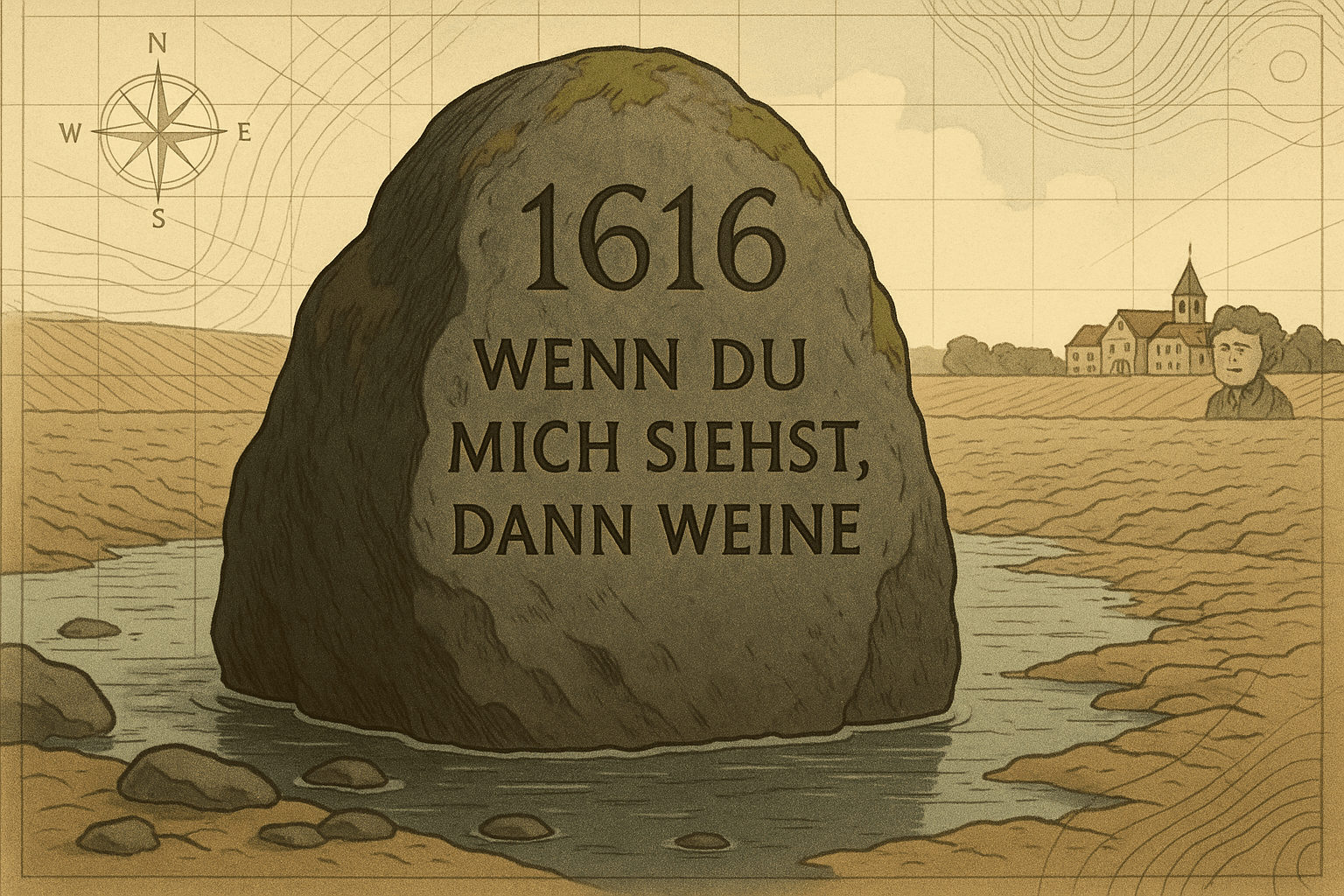
The Děčín Hunger Stone is a historical document in itself. While its oldest claimed marking dates to 1417, the oldest clearly legible inscription reads 1616. It is covered in the carved dates of subsequent droughts:
- 1707
- 1746
- 1790
- 1800
- 1811
- 1842
- 1868
- 1892
Most famously, a German inscription added in the late 19th or or early 20th century delivers a devastatingly simple warning:
“Wenn du mich siehst, dann weine.” (If you see me, then weep.)
Other inscriptions found on this and other stones provide more detail about the consequences. One carving from 1904 notes, “When this stone is seen, the Elbe’s shipping was at a standstill.” Another speaks of poor harvests, the high price of bread, and the suffering of the poor. They are, in essence, public service announcements carved in stone, communicating risk across generations.
More Than Just Rocks: A Centuries-Old Climate Archive
In the 21st century, the re-emergence of Hunger Stones during the severe European droughts of 2015, 2018, and 2022 has captured global attention. Today, we see them not just as historical curiosities, but as a visceral, pre-instrumental form of climate data. They are a proxy record—an indirect source of climate information—that tells a story of extreme hydrological events long before modern gauges and satellites existed.
Their increasing frequency of appearance serves as an alarming barometer for our changing climate. While our ancestors saw them once or twice in a lifetime, we are beginning to see them every few years. This aligns with scientific consensus that climate change is increasing the frequency and intensity of extreme weather events, including drought, in Europe.
However, it is crucial to add a layer of geographical nuance. Direct comparison of water levels between, say, 1616 and 2022 is not straightforward. The rivers themselves have changed. Over the last century, extensive river engineering—including the construction of dams, weirs, and the dredging of channels to facilitate modern shipping—has altered the riverbeds. In Děčín, for example, a weir built in the 1920s raised the riverbed, meaning the stone now becomes visible at a higher water level than it would have in centuries past. Despite this, the trend is undeniable. The conditions that reveal the Hunger Stones are occurring far more often than they used to.
The Rivers’ Enduring Warning
The Hunger Stones are a unique intersection of physical geography, human history, and climate science. They are monuments born of hardship, written in the universal language of fear and survival. For centuries, they were a local phenomenon, a river’s private memory shared only with those who lived along its banks.
Today, as they surface with disturbing regularity, their message has gone global. They are no longer just a record of past famines, but a potent symbol of our current climate crisis. The warning, “If you see me, weep”, speaks not only of the struggle for bread and the inability to transport goods, but of a future where the climatic stability our societies were built upon can no longer be taken for granted. The river’s memory has become humanity’s urgent warning.