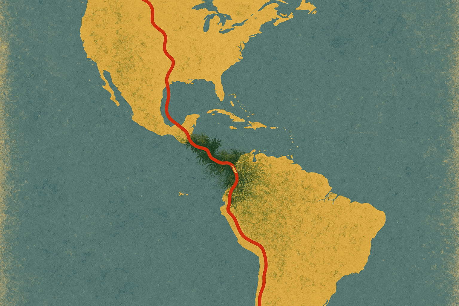
Imagine a single road trip that takes you from the frozen shores of the Arctic Ocean to the windswept tip of South America. A journey that traverses searing deserts, dense rainforests, and the world’s longest mountain range. This epic route isn’t a fantasy; it’s the Pan-American Highway, a network of roads that, in spirit and asphalt, stitches together two continents. More than just a transportation corridor, it’s a testament to a grand geopolitical dream and a stark reminder of the untamable power of nature.
A Dream Forged in Diplomacy
The idea of a hemispheric highway wasn’t born from a love of road trips, but from a vision of political and economic unity. In the late 19th and early 20th centuries, the nations of the Americas sought to foster closer ties, counterbalancing European influence. At a series of Pan-American Conferences, the concept of a highway was championed as a physical link to promote trade, tourism, and cultural exchange.
The Convention on the Pan-American Highway was signed in 1937, formalizing the project. While it was never a centrally funded, single construction effort like a national interstate system, the agreement encouraged member nations to connect their primary road networks into one continuous system. The United States, seeing it as a way to boost automobile exports and secure access to raw materials, provided technical and financial assistance to many Latin American countries. The highway became a symbol of “Pan-Americanism”—a dream of a hemisphere united by more than just geography.
The Journey North: From Tundra to Tropics
While the “official” Pan-American Highway has various starting points depending on the definition, the ultimate northbound traveler begins in Prudhoe Bay, Alaska. From here, the Dalton Highway cuts south through stark Arctic tundra, a land of permafrost and hardy wildlife.
The route connects to the famed Alaska Highway, a marvel of wartime engineering pushed through the vast Canadian wilderness in just eight months during World War II. It winds through the majestic Northern Rocky Mountains of British Columbia and the Yukon, passing through cities like Edmonton and Calgary before crossing into the United States. In the U.S., there is no single designated highway, but a network of Interstates carries the spirit of the route south. A traveler might cross the Great Plains, navigate the high-altitude passes of the Rockies near Denver, and feel the heat rise in the Chihuahuan Desert of Texas and New Mexico before reaching the Mexican border at El Paso or Laredo.
Crossing into Mexico, the geography transforms. The highway, now primarily Mexico’s Federal Highway 45 and then 85, climbs onto the great Mexican Plateau, flanked by the towering Sierra Madre Occidental and Oriental mountain ranges. It’s a journey through the country’s historic heartland, eventually descending from the high-altitude bustle of Mexico City towards the tropical climates of the south.
The Central American Isthmus
In Central America, the Pan-American Highway (designated as CA-1) becomes a single, vital artery. It snakes its way down a narrow, geologically active isthmus, a land bridge defined by a chain of volcanoes and frequent seismic activity. The route offers a stunning cross-section of the region’s physical geography:
- Guatemala: The highway navigates highlands dotted with volcanoes and valleys where Indigenous Maya communities flourish.
- El Salvador & Honduras: It cuts through the most densely populated regions of these countries, a corridor of commerce and daily life.
- Nicaragua: The road skirts the shores of the vast Lake Nicaragua, the largest lake in Central America, with its famous twin-volcano island, Ometepe.
- Costa Rica: Here, travelers face one of the route’s most notorious sections: the Cerro de la Muerte (“Summit of Death”). This high-altitude pass climbs to over 3,400 meters (11,000 feet), piercing the clouds and often shrouded in thick, dangerous fog.
- Panama: The highway crosses a monumental piece of human geography—the Panama Canal—over the impressive Bridge of the Americas before winding its way east toward its abrupt end.
The Darién Gap: The Jungle That Broke the Dream
Just east of the Panamanian town of Yaviza, the asphalt vanishes. This is the start of the Darién Gap, a formidable 106-kilometer (66-mile) stretch of dense, mountainous rainforest and swampland that separates Panama from Colombia. It is the only missing link in the entire Pan-American Highway.
The reasons for its incompletion are a complex mix of geography, ecology, and politics:
- Physical Geography: This is one of the wettest, most inhospitable places on Earth. Building a road through its unstable, marshy terrain and across its countless rivers would be an engineering nightmare of epic proportions, with staggering financial and maintenance costs.
- Environmental Concerns: The Gap is a biodiversity hotspot of global significance. Conservationists fear a road would lead to rampant deforestation and habitat destruction. Furthermore, it acts as a crucial natural barrier, preventing the spread of agricultural diseases like foot-and-mouth disease from South America northward.
- Human Geography: The region is the ancestral home of Indigenous peoples, including the Guna and Embera-Wounaan, whose way of life would be irrevocably altered by a highway. Today, the area is also a perilous, lawless corridor used by drug traffickers, smugglers, and desperate migrants, making it one of the most dangerous places in the hemisphere.
To cross the Darién Gap, travelers must bypass it, typically by taking a ferry or shipping their vehicle by container ship from Colón, Panama, to Cartagena, Colombia.
Southbound: The Andes, Deserts, and the End of the World
Picking up in Colombia, the Pan-American Highway enters its final, dramatic chapter. The route primarily hugs the western side of South America, tracing the spine of the Andes.
In Colombia and Ecuador, the road twists through breathtaking green valleys and past snow-capped volcanoes in a region known as the “Avenue of the Volcanoes.” It connects high-altitude capitals like Bogotá and Quito. Descending into Peru, the landscape shifts dramatically. The highway becomes a coastal road, a thin ribbon of pavement squeezed between the deep blue of the Pacific Ocean and the bone-dry foothills of the Andes. Here, it traverses the Atacama Desert, one of the driest places on the planet.
Further south, the highway splits. The main route cuts inland across the Andes into Argentina, descending into the vast, fertile grasslands of the Pampas before reaching the vibrant capital, Buenos Aires. From there, Ruta 3 leads south on a final, lonely stretch through the barren, windswept plains of Patagonia. The journey culminates on the island of Tierra del Fuego, ending in the city of Ushuaia—the southernmost city in the world.
From Arctic ice to Patagonian plains, the Pan-American Highway is more than a road. It’s an artery pulsing with the life of a hemisphere, connecting dozens of cultures and millions of people. While the Darién Gap stands as a powerful testament to the limits of human will against the force of nature, the 30,000 kilometers (19,000 miles) of completed road remain one of humanity’s greatest, if imperfect, achievements in uniting a continent.